
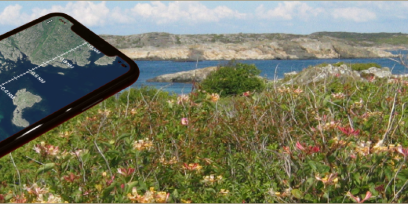
If you're the kind of hiker who can spend hours just looking at maps, CalTopo will feel less like a tool and more like a playground. At its core, CalTopo lets you layer different map sources, tweak contour visibility, experiment with shading, and build a map that matches exactly how you see the terrain. The result isn't just functional - it's often beautiful, detailed, and deeply personal.
But CalTopo isn't only about aesthetics. Under the surface, it's a highly capable planning tool. Its route builder is precise and flexible, allowing you to sketch out anything from a quick local walk to a multi-day backcountry adventure with confidence. Whether you're analyzing elevation profiles or fine-tuning a route to avoid tricky terrain, it gives you a level of control that most hiking apps simply don't offer.
In practice, CalTopo shines across the full hiking workflow. Many users start on desktop, where the large screen makes it ideal for creating and customizing maps, layering data, and preparing routes. Those maps can then be printed for offline use or synced to your phone, where the mobile app becomes a reliable companion for navigation and track-following in the field.
This combination of flexibility and depth is exactly why CalTopo has earned a strong reputation beyond recreational hiking. It's widely used by professionals, including search and rescue (SAR) teams, who rely on its advanced mapping capabilities when precision and situational awareness really matter.
In short, CalTopo bridges the gap between map artistry and serious backcountry planning - and does both exceptionally well.
When it comes to planning a multi-day trip - whether that's a summer tour through Romania's mountains, a scenic road journey through the Alps, or a backroads adventure across the Balkans - juggling routes, stops, accommodation and timing can quickly become overwhelming. That's where Furkot shines.
Furkot is a web-based trip planner that helps you build detailed itineraries with all of the elements you care about - from daily mileage and overnight stays to attractions, meals and scenic detours - all in one place. Instead of splintering your planning across spreadsheets, pinboards, and random map tabs, Furkot lets you design your trip the way you think about it: day by day, mile by mile, experience by experience.

Wikiloc is one of the most popular community-driven hiking platforms and probably the most internationally diverse one, with trail contributions from hikers all over the world. It's particularly popular in Southern Europe and South America, and since most of my hikes take place in the Balkan peninsula, it's a natural choice for me - there's a healthy density of routes shared by local hikers. That community aspect really matters when you're looking for reliable trails in your region.
Like all the other community-driven hiking platforms, Wikiloc is built around outdoor routes and allows people to:
- record hikes, walks, and other outdoor activities
- upload those tracks to a shared platform
- gradually build a personal history of outdoor trips
- discover routes created by others
- follow existing trails in the field
Map Marker is a true gem among location-based apps. It focuses on one core idea - saving and organizing places - and does so exceptionally well through its Android, iOS, and web apps. Instead of trying to be a full navigation or fitness platform, Map Marker excels at what many outdoor and travel apps surprisingly overlook: giving you a clean, structured way to collect locations that matter to you.
Whether you’re marking mountain peaks, viewpoints, monuments, trees, parking spots, or future hiking ideas, Map Marker lets you organize locations into folders, assign icons, add notes, and view everything clearly on a map. It stays lightweight and intuitive, yet powerful enough to export your data (GPX/KML) and integrate with other mapping or navigation tools when needed.
The result is an app that feels deliberately focused - quick to use in the field, pleasant to browse later on the web, and flexible enough to fit into more advanced outdoor workflows.
Geocaching is a global treasure hunt that combines maps, puzzles, outdoor exploration, and a touch of detective work. All you need is your smartphone. If you’ve ever wished the world had just a bit more mystery, geocaching might be the perfect hobby for you.
In this article, we’ll look at what geocaching is, why it has become so popular, and which Android and iOS apps offer the best experience today.
Locus Map is a great outdoor navigation app that I've been playing with and enjoying lately. It is an extremely configurable and powerful app which simply can't be reviewed in one blog post, so I will cover some specific features as I explore them. In this first article about Locus Map I will talk about location sharing.
There are many reasons you might want to share your location, whether as a one-time manual update or through real-time tracking. For hikers, one of the most important reasons is when hiking alone - having someone know your whereabouts could be lifesaving in the event of an accident or emergency.
It is also important to be able to share some specific location on the map, for example a meeting point, a campsite or simply a waypoint, so that others can easily find it.
There are various different ways for location sharing and this app seems to cover them all.

The condition of your hiking gear - especially your shoes or boots - plays a major role in your comfort, safety, and overall experience on the trail. Over time, hiking footwear gradually loses its support, grip, and cushioning, often without obvious signs. That's where gear tracking becomes a valuable tool.
Gear tracking is a simple but powerful feature available in many fitness apps. It lets you log the use of specific gear, like hiking shoes, backpacks, or trekking poles, alongside your recorded activities. By automatically keeping track of distance, time, and terrain, you can monitor how much wear your gear has experienced and know when it's time for maintenance or replacement.
Tracking your hiking gear helps prevent discomfort and injuries that can result from worn-out equipment. It also ensures that you're getting the best performance out of your boots and other gear for every adventure. Plus, it's satisfying to look back and see how many miles your favourite pair of boots have carried you!

gpx.studio is a free web app that provides various tools for editing your GPX files. GPX is one of the formats used by your GPS devices to record your tracks. Among other tools, this web app provides a tool to remove wrongly recorded points. In this video I demonstrate how you can remove spurious (fake) points from your GPX recorded tracks using gpx.studio
Despite it's name which suggests a viewer, GPX Viewer is a very capable mobile app for navigation, route following and track recording. It is reliable, provides a useful set of features and a nice set of maps that are visually pleasing and useful for hiking. It comes in two versions on Android, the basic free version and the paid Pro version. On iOS it comes only as a paid version.
In this article we will review the Android Pro version, since it comes with a couple of important features that are not available in the free one:
- offline maps
- track recording
The Android Pro version is available for a one-time payment of around 8.50 USD, which in our opinion is well worth the price for a very handy offline navigation app.

GPS Locker is a utility designed to enhance the performance and stability of GPS connections on your Android phone. It is particularly useful in scenarios where maintaining a stable, continuous GPS signal is crucial.
I find it especially useful to:
- prevent losing the GPS connection when switching between GPS-using apps
- enhance the accuracy of the geotagged location in photos I take with my mobile phone
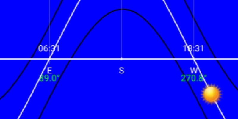
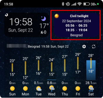
Ever wondered exactly when it truly gets dark? While sunset times are easy to find, it's harder to know how long you’ll have natural light before reaching for your flashlight. LunaSolCal is one of the apps that can provide you this information and I chose it over the other similar apps because it can be configured to display the civil twilight period in a simple widget on my Android phone:
My Lightning Tracker is a great app for tracking lightning strikes worldwide in close to real time. The feature to alert you of lightning strikes close to you can be very valuable for hikers, specially during the summer when sudden thunderstorms are not rare.
Gaia GPS is a mapping and navigation app for Android, iPhone and the web. It is quite popular in the US and Canada due to a large number of specialized map layers for these countries, such as hunting, fishing, historic, public land and others, as well as some premium basic maps such as National Geographic Trails Illustrated. Hikers in the rest of the world can use the maps that are usually available with other navigation apps, which are based on OpenStreetMap.
The web app is a great choice for route planning, while the mobile app excels in navigation, track recording and aims to do so in following routes. Together, the web and mobile apps provide a nice platform for storing and organizing your recorded tracks, planned routes, waypoints and even photos.
The web and mobile apps are synced through the Gaia Cloud linked by your user account. This makes it a great platform for planning routes on your desktop and having them readily available in your app, without having to do any manual file transfers.
Gaia GPS was generally well regarded in the hiking community until it was purchased by Outdoor Magazine in 2021 and became part of the Outside+ suite of products. That's when the costs of using the app started to raise, together with privacy concerns among the community.


Funded by the US National Science Foundation, implemented at the University of Minnesota, the "Flyover Country" mobile app is a very useful, unique and free app for Android and iOS, which enriches the exploration experience using offline maps whether you're flying, travelling by car, or trekking through nature's wonders. It is voted one of the best science apps available today by Popular Mechanic.

Gaia GPS is a complex app, which has both a mobile and a web version. In this article we will cover just a small but very useful functionality of it's web app - route planning.
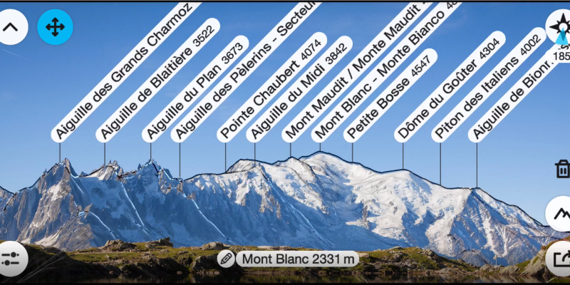
PeakFinder is an app designed to help users identify mountains and peaks in their surroundings. The app uses augmented reality technology, the GPS receiver and built-in sensors of your mobile device to overlay information about the names and elevations of mountain peaks onto the camera view.
This little cool app is designed for classical orienteering and provides various features to help users find the direction and distance to their desired destinations. It is a versatile tool for orienteering enthusiasts and outdoor adventurers who need a digital solution for navigation. It combines traditional map and compass techniques with modern technology to assist users in finding their way to a specific location.
This is the first app I use when I need a quick insight of the direction and aerial distance to a geographical mark. It's also great for figuring out what village, river, lake or mountain you're looking at in the distance, and how far it actually is. I find this to be a very satisfying and nice tool. But there's a caveat - it only works if you have an internet connection as it relies on online Google maps. It would be fantastic if it could work with offline Google maps, but currently it does not.
Glympse is an application that specializes in real time location sharing. A free version is available with features that are sufficient for hikers.
Glympse is a fast, free, and simple way to temporarily share your real-time location with anyone. The tracking is based on GPS, is temporary and secure – and Glympse recipients don’t need to download an app to see the shared location - they will instead receive a link which they can open in any web browser, on their computer or mobile. The web page in the browser will display a map with approximately the last kilometer of the shared trail.
AGPS-TrackerOm is an interesting Android application. It's main function is to follow preloaded tracks and record your tracks, and tries to do so reliably - ensuring that the GPS data is recorded at all times, even when the phone goes into stand-by mode. It can also provide enhanced accuracy of your current elevation, by using altitudes from NASA-generated Digital Elevation Models (DEMs) instead of the GPS-provided elevation which can be quite inaccurate.
AGPS-TrackerOm (previously called A-GPS Tracker++), differs from the lighter version, A-GPS Tracker in the following:
- AGPS-TrackerOm uses offline maps maintained by OpenStreetMap, which you need to preload. The "lighter" A-GPS Tracker uses Google maps which are not available offline.
- You can download Digital Elevation Models (DEM) which allow the app to display altitude contour lines and provide DEM altitude along with GPS altitude, the former being more accurate