When it comes to planning a multi-day trip - whether that's a summer tour through Romania's mountains, a scenic road journey through the Alps, or a backroads adventure across the Balkans - juggling routes, stops, accommodation and timing can quickly become overwhelming. That's where Furkot shines.
Furkot is a web-based trip planner that helps you build detailed itineraries with all of the elements you care about - from daily mileage and overnight stays to attractions, meals and scenic detours - all in one place. Instead of splintering your planning across spreadsheets, pinboards, and random map tabs, Furkot lets you design your trip the way you think about it: day by day, mile by mile, experience by experience.
Wikiloc is one of the most popular community-driven hiking platforms and probably the most internationally diverse one, with trail contributions from hikers all over the world. It's particularly popular in Southern Europe and South America, and since most of my hikes take place in the Balkan peninsula, it's a natural choice for me - there's a healthy density of routes shared by local hikers. That community aspect really matters when you're looking for reliable trails in your region.
Like all the other community-driven hiking platforms, Wikiloc is built around outdoor routes and allows people to:
- record hikes, walks, and other outdoor activities
- upload those tracks to a shared platform
- gradually build a personal history of outdoor trips
- discover routes created by others
- follow existing trails in the field
Map Marker is a true gem among location-based apps. It focuses on one core idea - saving and organizing places - and does so exceptionally well through its Android, iOS, and web apps. Instead of trying to be a full navigation or fitness platform, Map Marker excels at what many outdoor and travel apps surprisingly overlook: giving you a clean, structured way to collect locations that matter to you.
Whether you’re marking mountain peaks, viewpoints, monuments, trees, parking spots, or future hiking ideas, Map Marker lets you organize locations into folders, assign icons, add notes, and view everything clearly on a map. It stays lightweight and intuitive, yet powerful enough to export your data (GPX/KML) and integrate with other mapping or navigation tools when needed.
The result is an app that feels deliberately focused - quick to use in the field, pleasant to browse later on the web, and flexible enough to fit into more advanced outdoor workflows.
The condition of your hiking gear - especially your shoes or boots - plays a major role in your comfort, safety, and overall experience on the trail. Over time, hiking footwear gradually loses its support, grip, and cushioning, often without obvious signs. That's where gear tracking becomes a valuable tool.
Gear tracking is a simple but powerful feature available in many fitness apps. It lets you log the use of specific gear, like hiking shoes, backpacks, or trekking poles, alongside your recorded activities. By automatically keeping track of distance, time, and terrain, you can monitor how much wear your gear has experienced and know when it's time for maintenance or replacement.
Tracking your hiking gear helps prevent discomfort and injuries that can result from worn-out equipment. It also ensures that you're getting the best performance out of your boots and other gear for every adventure. Plus, it's satisfying to look back and see how many miles your favourite pair of boots have carried you!
gpx.studio is a free web app that provides various tools for editing your GPX files. GPX is one of the formats used by your GPS devices to record your tracks. Among other tools, this web app provides a tool to remove wrongly recorded points. In this video I demonstrate how you can remove spurious (fake) points from your GPX recorded tracks using gpx.studio
Gaia GPS is a mapping and navigation app for Android, iPhone and the web. It is quite popular in the US and Canada due to a large number of specialized map layers for these countries, such as hunting, fishing, historic, public land and others, as well as some premium basic maps such as National Geographic Trails Illustrated. Hikers in the rest of the world can use the maps that are usually available with other navigation apps, which are based on OpenStreetMap.
The web app is a great choice for route planning, while the mobile app excels in navigation, track recording and aims to do so in following routes. Together, the web and mobile apps provide a nice platform for storing and organizing your recorded tracks, planned routes, waypoints and even photos.
The web and mobile apps are synced through the Gaia Cloud linked by your user account. This makes it a great platform for planning routes on your desktop and having them readily available in your app, without having to do any manual file transfers.
Gaia GPS was generally well regarded in the hiking community until it was purchased by Outdoor Magazine in 2021 and became part of the Outside+ suite of products. That's when the costs of using the app started to raise, together with privacy concerns among the community.
Gaia GPS is a complex app, which has both a mobile and a web version. In this article we will cover just a small but very useful functionality of it's web app - route planning.
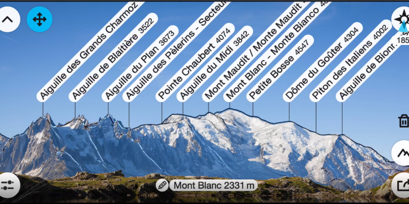
PeakFinder is an app designed to help users identify mountains and peaks in their surroundings. The app uses augmented reality technology, the GPS receiver and built-in sensors of your mobile device to overlay information about the names and elevations of mountain peaks onto the camera view.


