Gaia GPS is a mapping and navigation app for Android, iPhone and the web. It is quite popular in the US and Canada due to a large number of specialized map layers for these countries, such as hunting, fishing, historic, public land and others, as well as some premium basic maps such as National Geographic Trails Illustrated. Hikers in the rest of the world can use the maps that are usually available with other navigation apps, which are based on OpenStreetMap.
The web app is a great choice for route planning, while the mobile app excels in navigation, track recording and aims to do so in following routes. Together, the web and mobile apps provide a nice platform for storing and organizing your recorded tracks, planned routes, waypoints and even photos.
The web and mobile apps are synced through the Gaia Cloud linked by your user account. This makes it a great platform for planning routes on your desktop and having them readily available in your app, without having to do any manual file transfers.
Gaia GPS was generally well regarded in the hiking community until it was purchased by Outdoor Magazine in 2021 and became part of the Outside+ suite of products. That's when the costs of using the app started to raise, together with privacy concerns among the community.
Main Features
The main features of Gaia GPS are:
- Route planning - you can plan routes both through the web app or directly on the mobile app
- GPS navigation - watch your movements on a variety of maps, add waypoints, take photos
- Follow a route - follow a route you created or imported
- Track recording - record your hike
- Organize recorded tracks, created or imported routes, waypoints and photos
Instructions for using the app are available at the Gaia GPS website.
Gaia GPS Web App
Route Planning
The web app is one of the best tools around for planning a route. The mobile app provides the same feature, but planning a route on a large monitor is much more convenient. We've outlined the process in a separate post. The nice thing is that once you save the route in your web app the route is readily available for you to use on your mobile Gaia GPS app, assuming the "Sync with GaiaCloud" option is enabled.
Organizing Tracks
The web app is also convenient for browsing through the collection of recorded tracks, routes planned through the Gaia website or uploaded from other sources, marked waypoints and photos. The various resources are available through your profile's menu:

Note that the resources can be organized into folders, which is very convenient.
Even though the photos taken by smartphones are nowadays usually geotagged so the location where they were taken can be traced back, a nice Gaia feature that may be interesting to some folks is that Gaia allows you to store and organize collections of photos from your trails in the app itself. Here is an example of a photo that was taken while recording a track using the Gaia GPS mobile app, with the exact location of the generated waypoint.
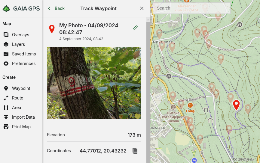
Note that the waypoints are available separate from the recorded tracks!
Gaia Mobile App
Maps
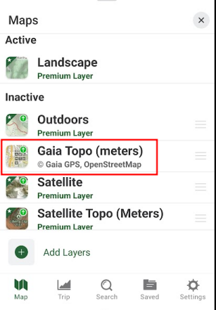
The free Gaia plan comes with a limited set of maps and they can only be displayed while you're online (have an internet connection). This means that if you're without an internet connection you won't be able to navigate using Gaia GPS. The set of maps provided in the free plan are based on OpenStreetMap maps, probably slightly enhanced by Gaia as they are labelled "Gaia Topo":
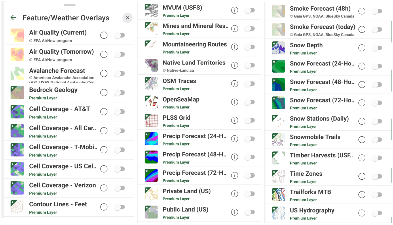
For those living or hiking in US or Canada, Gaia GPS provides probably the richest set of premium maps in one package. It does however come at a price of US$60/year. Examples of maps are National Geographic Trails Illustrated, historic maps, fishing, hunting, snow forecast, avalanche forecast, timber harvest, private/public land, cell coverage, air quality and so on. Here is a subset of the long list:
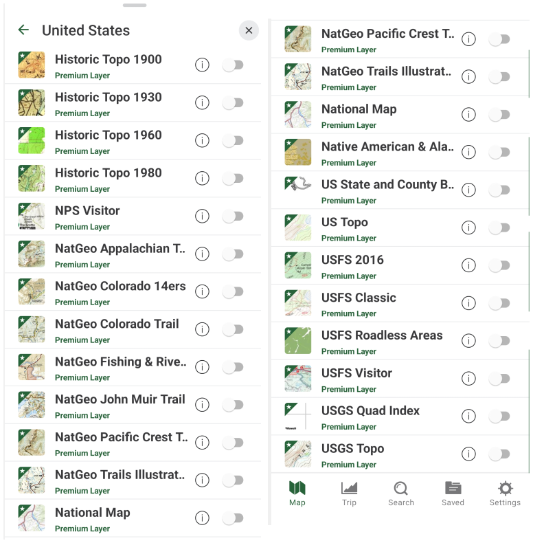
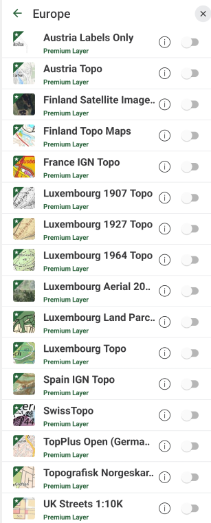
For those living outside North America the choice of premium maps is very limited. As an example, this is the list of Premium maps for Europe:
GPS Navigation
GPS navigation is the basic feature of this app - the "Map" tab is the active one when you start the app. You can navigate with or without recording your track. While navigating you view your position on the map, you can mark waypoints and take photos, which automatically creates a waypoint. You don't have to be recording a track to perform these operations, which is nice and a bit uncommon among hiking apps, which usually attach waypoints to recorded GPX tracks.
Location button
If the map is not centered at your location, click the "triangle-like" location button in the left bottom part of the screen. This button has three states or navigation modes of operation. You move through the states by clicking the button.
Icon |
Navigation Mode |
Description |
|---|---|---|
| Off | Map is oriented north up and remains stationary as you move, so eventually your position will get off the screen unless you drag the map. | |
| Compass mode | Map is oriented north up and pans automatically to keep your location centered. Arrow remains centered as you move. | |
| Course mode | Map rotates as you rotate your phone, mirroring your direction. Arrow remains centered as you move. |
Compass
At the top of the map you can find the compass bar and a small compass needle. The compass bar shows the azimuth of your heading, that is degrees from north in the clockwise direction. The red arrow of the compass needle always points to north.
As an example, in the following screenshot I'm heading approximately south-south-east (SSE), at an azimuth of around 155°. If I need to head south I can move my device until the bar points at "S".
Note that the compass always indicates your device's orientation, regardless of the maps display! This means that the compass needle won't change positions if you switch the navigation mode from "compass mode" to "course mode"
Recording a Track
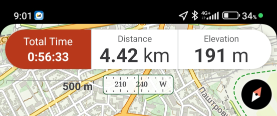
To start recording a track simply click the red "record" button at the top of the Map screen. You don't have to do anything until you're ready to end the recording, for which you click the same button again and either end the recording, pause it or delete it. While the track is being recorded, the top bar shows the main information about the recorded track, for example:
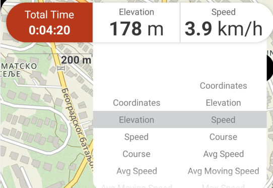
The stats in the top bar are configurable - clicking on the stats you get scrolling fields where you can easily select what you want to be displayed:
You get more information about the current track in landscape mode:

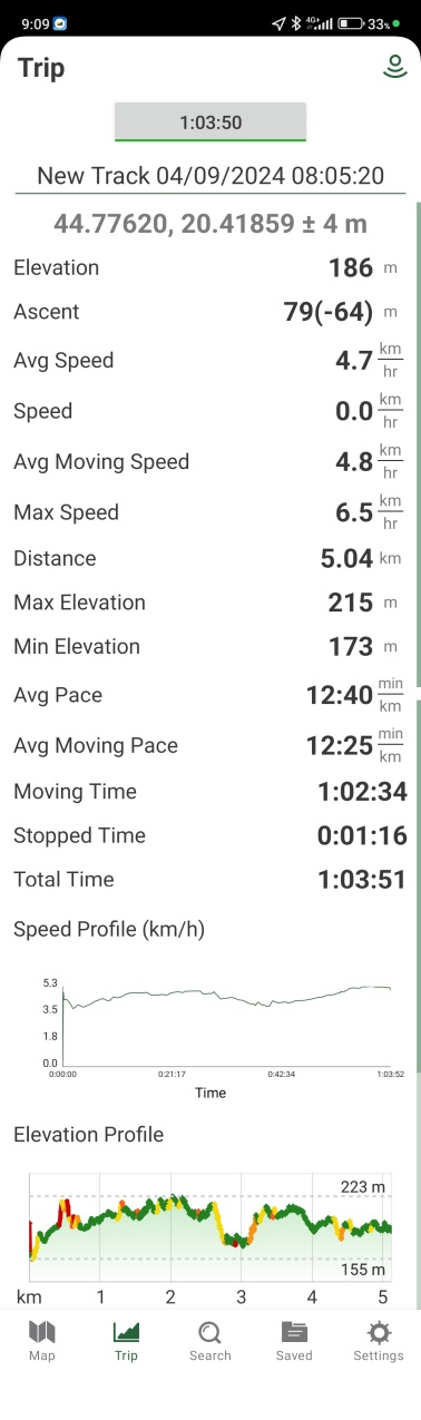
To view all the recorded trip information, there is a separate Trip tab, which contains all the usual hiking stats, including a nice speed and elevation profile.
I should note that I haven't had any issues with the recordings, no dropped sections as with some other apps, which is quite amazing having in mind that the app hasn't requested any extra permissions related to battery savings.
Exporting Tracks
You can export recorded tracks from both the mobile and the web app. A nice feature of Gaia GPS is that the recorded tracks are readily available in the web app, so you can dig into the details in the comfort of your desktop.
In the "Saved" tab of the mobile app you will find a list of all the recorded tracks, along with imported routes, waypoints, etc. Clicking on the track brings up a screen with details about the track:

Clicking on the "Export" item you get the option to share/send the track in GPX, KML or CSV formats.
The "My Tracks" section of the web app provides even more options, such as embedding the track in your html. This may be an outdated feature, but useful for some old-school folks like myself :)
One info worth mentioning is that exported GPX doesn't contain waypoint information. Gaia GPS keeps the waypoints separate from tracks - something to be aware of if you plan on exporting your GPX tracks to other platforms.
Following a Track
We can see several interesting options related to following a track in the above image:
- Show on map - shows the track/route on the map
- Driving directions - provides driving directions from your current location to the start of the track
- Download map along route - download the map along the route for offline usage (Premium only)
- Guide me - this is the option for turn by turn instructions once you're on the followed track
There are very detailed instructions for turn-by-turn directions provided by Gaia, but I just couldn't get them to work correctly on my Android phone. The main issues I had are:
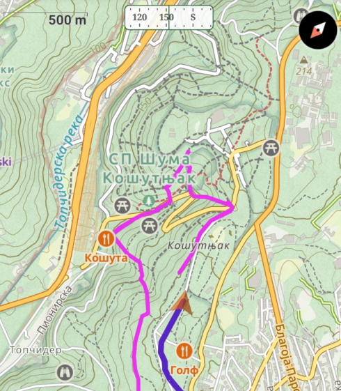
(1) The "guide me" part of the status bar overlaps with the regular content of the bar, making it ugly and hard to read, as can be seen at the top of this screenshot:

(2) When I'm not on track, Gaia suggests I take a straight line back to the last position when I was on track (see the red line in the above screenshot). Maybe this makes sense, but I would expect it to route me through existing paths, not just a straight line. Also, there were closer points on the route that it could direct me to!
(3) When I used the "Guide Me for a tap marker or a waypoint" feature (Gaia terminology) the turn by turn instructions only seem to be available for driving roads, not for hiking paths. Maybe I was doing something wrong, although I tried really hard to get it to work so good chances are other users would have problems too.
Overall, all of these look like software bugs, perhaps platform or version specific, that could be rectified in some future releases but the point is that you have to try this out yourself in a safe test environment before relying on it in the wild!
On the positive side, I really liked the info in the "guide me" part of the status bar, the ETA is useful (you can see it say "49:35" on the second image above), and the fact I can switch between directions (clicking on the left green button) is kind of cool.
Pricing
These are the pricing plans as of 2024:
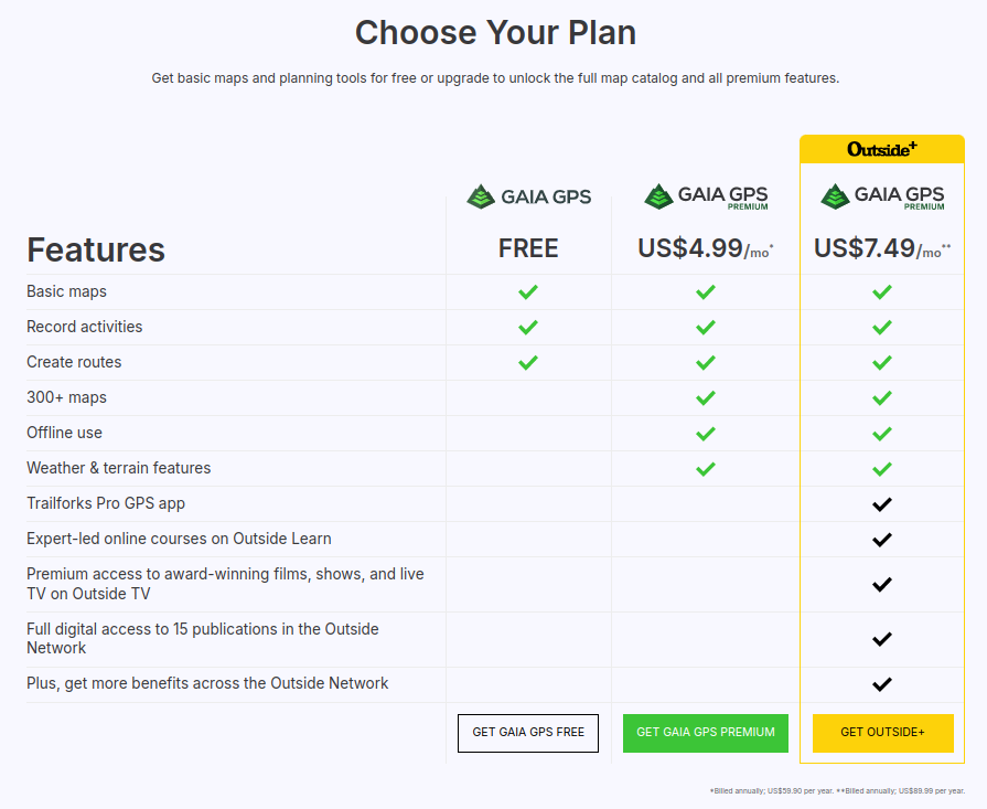
The fine print says US$59.90 per year for the Premium and US$89.99 for the Outside+ plan.
If you're using Gaia GPS for route planning alone (as I do), you can pass with the free plan.
If you're outside North America and you need "Offline use" (navigation without internet connection), you'll have to pay the $60/year or use another app (they do exist!).
If you're in North America it may make sense to pay the $60/year since the specialised basic and layer maps provided by Gaia GPS for the US and Canada are of excellent quality and well worth the price.
Rating
As of September 2024, the app has been downloaded 1M+ times on Google Play, and has a rating of 4.8 out of 17.4K reviews. Impressive!

Apple store rating:

Final Verdict
The mobile Gaia GPS app is generally intuitive and a joy to use, except for following a route which I got frustrated with. It has pleasing graphics, all the features one would expect from a good navigation app and it provides it in a nice and intuitive interface. However, the free plan doesn't come with support for offline usage, which means the free mobile app is practically unusable in any remote area. The current US$60/year price for the Premium subscription doesn't seem worth the price, unless you are hiking in US or Canada, for which the Premium subscription comes with a variety of specialised maps (for hunting, fishing, history, etc).
The web app can still be used with the free plan to create routes, but have in mind that the generated gpx files will have to be manually transferred to your navigation app of choice.
Comments
Powered by FastComments