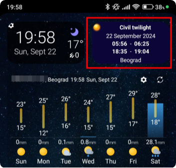
Ever wondered exactly when it truly gets dark? While sunset times are easy to find, it's harder to know how long you’ll have natural light before reaching for your flashlight. LunaSolCal is one of the apps that can provide you this information and I chose it over the other similar apps because it can be configured to display the civil twilight period in a simple widget on my Android phone:
My Lightning Tracker is a great app for tracking lightning strikes worldwide in close to real time. The feature to alert you of lightning strikes close to you can be very valuable for hikers, specially during the summer when sudden thunderstorms are not rare.
Gaia GPS is a mapping and navigation app for Android, iPhone and the web. It is quite popular in the US and Canada due to a large number of specialized map layers for these countries, such as hunting, fishing, historic, public land and others, as well as some premium basic maps such as National Geographic Trails Illustrated. Hikers in the rest of the world can use the maps that are usually available with other navigation apps, which are based on OpenStreetMap.
The web app is a great choice for route planning, while the mobile app excels in navigation, track recording and aims to do so in following routes. Together, the web and mobile apps provide a nice platform for storing and organizing your recorded tracks, planned routes, waypoints and even photos.
The web and mobile apps are synced through the Gaia Cloud linked by your user account. This makes it a great platform for planning routes on your desktop and having them readily available in your app, without having to do any manual file transfers.
Gaia GPS was generally well regarded in the hiking community until it was purchased by Outdoor Magazine in 2021 and became part of the Outside+ suite of products. That's when the costs of using the app started to raise, together with privacy concerns among the community.